冬の雪情報 yuki - cold wave December 12, 2014
December 12 / 12月 12日
More snowman in the forecast now for the next few days, -4℃.
This kanpa is also in the USA (with hurricane-like storm) and Europa, while at the North Pole it is going to be warmer for the next few days.
A strange seldom weather pattern, maybe caused by El Ninyo.
- NHK news - Japan braces for 2nd round of cold
Dec. 12, 2014 -
Japan is bracing itself for another round of cold weather that could bring heavy snow to a wide area.
The Meteorological Agency says a very cold air mass is coming down over Japan. It's predicted to stay from Friday evening through the weekend.
The agency warns that the Japan Sea side of northern to western Japan may have heavy snow. It also warns of snow in mountainous areas along the Pacific side of the country.
Last weekend, a cold air mass brought earlier-than-usual heavy snow to a wide area. Some parts of Japan were paralyzed by interruptions in electricity and stranding of cars and trains.
Tokushima, a comparatively warm prefecture on the western island of Shikoku, was largely affected by the unexpected snow. More than 800 households in mountainous areas were isolated for several days.
Residents are now getting ready for further heavy snow by stocking up on necessities, including deicing agents for roads.
The Meteorological Agency says that in the northern island of Hokkaido gusts of wind of more than 120 kilometers an hour will be accompanied by snow from early Friday.
December 13 / 12月 13日
朝 -1℃、 昼間 3℃! 夜 0℃
White snow cover in the morning - more in the forecast.
It snowed lightly among sunshine, snow all melted,
but by 3 in the afternoon the temperatures turned toward 0 again.
Very very VERY strong wind (8) until tomorrow.
December 14 / 12月 14日
朝 -3℃、 昼間 1℃! 夜 0℃
Just a light white snow cover on everything. Ice-cold wind-gusts all day.
December 15 / 12月 15日
朝 -0℃、 昼間 5℃! 夜 2℃
Just a light white snow cover on everything.
- forecast of minus 6, minus 5 for Wednesday and Thursday.
- NHK news -
Cold mass is bringing heavy snow to parts of Japan
Dec. 15, 2014 - Updated 06:07 UTC+9
Japan's Meteorological Agency says a strong cold air mass is bringing heavy snow to parts of the Japan Sea Coast and mountainous areas.
Mountainous regions in Niigata and Nagano Prefectures have had snowfall of up to one meter in 24 hours. Snow has also covered some plains on the Pacific Coast in central Japan.
Tokyo registered its first snow of the season when sleet fell on Sunday evening. It is the second-earliest snowfall in the capital in a decade, 20 days earlier than the average year and six days earlier than last year.
The cold mass will bring more snow to some parts of western Japan through Monday morning and to northern Japan, mostly in mountainous regions, until around noon as it gradually moves east.
The agency is warning against traffic disruptions, heavy snow on power cables and trees, lightning and gusty winds.
The agency is also asking people in heavy snow regions to watch out for avalanches and snow falling from roofs.
December 16 / 12月 16日
朝 1℃、 昼間 2℃! 夜 1℃
Rain / sleet all day in the forecast. tomorrow -2℃
- NHK news -
Heavy snow disrupts rail services
More than one meter of snow has accumulated in mountainous areas in Niigata, Yamagata, Nagano, and Gifu prefectures.
Passengers on 2 express trains in Niigata had to stay on board the trains overnight because service was halted due to a power outage.
Also in Ishikawa Prefecture, dozens of stranded travelers spent the night in trains at a station.
Service on part of the Yamagata Shinkansen line was temporarily suspended due to downed power lines.
The Meteorological Agency says winds are likely to intensify between Tuesday and Thursday around the country bringing more snow to wide areas.
The agency is warning of traffic disruptions, snow building up on power cables and trees, thunder and gusting winds.
weather pattern forecast for December 17

a typhoon-like low pressure coming "bakuhatsu"
very fast, very low, like an explosion
In Hokkaido warnings are out not to leave home . . . to stay safe.
Tomorrow is strong storm warning here too, wind of 11.
.......................................................................
December 17 / 12月 17日
朝 -3℃、 昼間 -1℃! 夜 -3℃
Thick white cover outside.
Snow in the forecast all day, daily high maybe zero. .
Yet it did not snow anymore here. Daily high just minus 1.. .
Cold blast lasting until December 18.
The Meteorological Agency says Hokkaido could see a potentially violent snow storm of an magnitude seen "once in a few years."
The coldest day so far !
- NHK News -
Snowstorm hits northern Japan
Dec. 17, 2014 - Updated 15:39 UTC+9
A strong snowstorm is hitting northern Japan and other areas on Wednesday, paralyzing road and air traffic.
The country's meteorological agency says 2 low-pressure systems as strong as a typhoon off the northern island of Hokkaido are bringing the snow and gusts to the island and northeastern Japan.

Gusts exceeded 130 kilometers per hour at Erimo Point in southern Hokkaido. Around 70 centimeters of snow has fallen in the eastern part of the island in the past 24 hours.
The storm cancelled more than 420 flights in and out of the region. Several thousand households lost electricity. Around 1,100 schools were closed in northern and eastern Hokkaido.
The storm also caused high tides, flooding residential areas in Hokkaido's coastal city of Nemuro.
In the northeastern part of Japan's main island Honshu, a branch line of Shinkansen bullet trains halted operations.
The storm brought many cities in western Japan their first snow of the year, though the amount was small.
The weather agency says the lows will soon combine into a storm system with a strength seen only every several years. It's warning people, especially in Hokkaido, to stay indoors.
It adds that up to 1 more meter of snow is likely by noon on Thursday in areas on Honshu's Japan Sea coast and mountainous regions.
(It was the first time we have seen a town under water in winter snow . . .!)
.......................................................................
December 18 / 12月 18日
朝 -4℃、 昼間 1℃! 夜 -1℃
5 cm snow cover in the morning.
First time to shovel the roads free!
Snow and sunshine, but more snow . . . yet our roads are free.
December 19 / 12月 19日 (Friday)
This cold wave seems over . . . but the next snowman is already in the forecast for Sunday.
:::::::::::::::::::::::::::::::::::::::::::::::::::::::::::::::::::::::::::::::::::::::::::::::::::::

First Snow 2014 - December 12 / 12月 12日 初雪
- back to
. 冬の雪情報 yuki - snow MEMO 2014 .
:::::::::::::::::::::::::::::::::::::::::::::::::::::::::::::::::::::::::::::::::::::::::::::::::::::
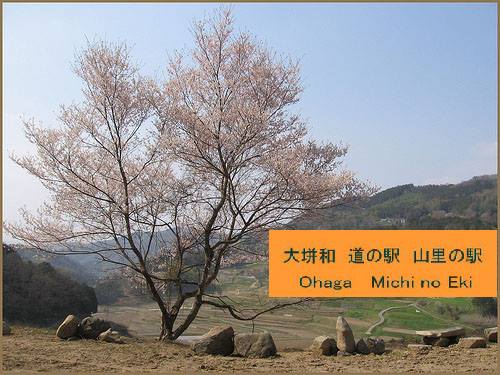
大垪和 。。。道の駅に戻る – Michi no Eki - BACK
岡山県美咲町大垪和西
:::::::::::::::::::::::::::::::::::::::::::::::::::::::::::::::::::::::::::::::::::::::::::::::::::::
worldkigo


No comments:
Post a Comment